
Princess Louisa Inlet & Chatterbox Falls
- Jaci Bryant
- Jun 21, 2022
- 4 min read
Updated: Jun 22, 2022

June 20, 2022
[ 62 NM, 2.5 hours ]
In planning for this trip, I reached out to our yacht club friends for their not to miss places. I spotted them on a Google My Maps and roughly estimated our time/distance to come up with a timeline for our 2 weeks. What I had was more places than we had time to see. Princess Louisa Inlet was going to need to be cut from the list. I Googled and it looked to have a spectacular waterfall, but I already had Teakerne Arm on our route, so we wouldn’t miss the waterfall experience. A week before we were set to leave, a yacht club Steak Fry and decades of experience set us straight. We would be foolish to skip Princess Louisa.
“It is Yosemite Valley, the Fjords of Norway and many other places all wrought into the background of our conifer forests of the Pacific Northwest.” - James F. MacDonald
We departed Schooner Cove with one of the few larger crossings we will have for our trip. It is 20 miles to crossover the Malaspina Strait from Dolphin Beach. Hatches were battened for our rolling seas and coffee consumed to log watch! What we got was the smoothest water we have had, and we have had none of it. It looked and felt like a morning lake. It also made debris watching a little easier. Those logs still bop up in down in smooth water, though.
Leaving from the underside of Texada Island we entered into the Agamemnon Channel. This where the life changing views start revealing themselves. There are some homes along our 35-mile cruise to the base of our destination, but they are sparce and designed to blend away to a nearly untouched waterway of beauty. The waters ranged from 800 feet to over 2000 feet deep through the channel, making the massiveness of the views and our significance to it feel even smaller. Our glass like water was icing on the cake for sure. Don’t think there weren’t logs, still lots of logs.
Our 2.5 hour cruise brought us to Malibu Rapids. We had researched this area by way of conversation with other boaters and YouTube videos. We knew we had to enter at a slack tide as the tide rips could be up to 9 knots. High tide was 10:50 am and we had given ourselves plenty of time to float out front of the rapids and wait for the safe time to enter, as was suggested. It was 9:00 am when we rounded the corner to Malibu Rapids. I was continually crossing from port to starboard on the stern to get pictures and paid no attention to how far we had gone. The waters were as calm as the rest of our trip and I had to verify that we had already made it through, but we crossed them without me even noticing.
"Glaciation of millennia past carved the magnificent granite-walled gorge through the snow-tipped mountains that rise sharply from the water’s edge to heights in excess of 2,100 metres (7,000 feet). As placid as a mountain lake, the ocean waters of Princess Louisa Inlet move constantly with the tides, but currents are practically nonexistent, except for the seven to ten-knot Malibu Rapids at the entrance. The inlet, almost completely enclosed, is 300 metres (1,000 feet) deep and never over 800 metres (1/2 mile) wide in its eight-kilometre (five-mile) length." - BC Parks
What I thought was the most beautiful cruise just turned into a split in the heavens. The mountains surrounding us are up to 7,000 feet and they feel as though you could reach out to touch them. The vertical rock on either side of us is layered with 60’ conifers for more stories than I could count. There are waterfalls of all sizes cascading on both sides of us for miles. It is difficult to put into words just how small we are in comparison to this place, but we now understand the need to be here.
The inlet ends at Chatterbox Falls. Think Romancing the Stone because there was surely a large green jewel worth killing for behind that powerful wall of water. The start of Chatterbox can be seen in a switch back coming down from its mountain top and you can see the mist explosion long before you can see the main attraction.
There are two mooring buoy locations and several buoys to choose from, as well as a dock with a front row seat of Chatterbox Falls. This is the location we directed our port side tie to. It also made for easy convenience on pup needs and what we thought would be an afternoon hike. Trapper’s Cabin is a hike to the top of the falls. There is a warning sign of the 12 deaths that have been recorded for the almost 2000’ of elevation gain in a 2 mile trip estimated at 4 hours. Our group isn’t THAT group, so we figured we could head up for some and turn back at any point. That point was 10 minutes in. It is muddy, it is slick, it is steep, and as the sign said, “BC does not recommend it.”
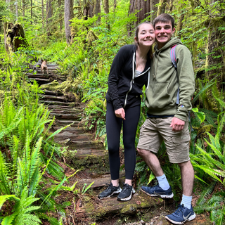
We opted to head to Provincial Park, a short dinghy ride away and one of the spots you could moor on a buoy outside of MacDonald Island. It has an easy loop with no posted signs of death. BC approved! It is 1 mile through a squishy floored forest that feels magical. Like a door in a tree is just waiting to be found with little people covered in sparkles.
The goal for them may be the same, but how they get there, and the path they take is out of our control.
We ended our water touring with a slow motor back on the dinghy to get closer to some of the smaller falls, and I think for Dave to get the kids intentionally wet. The smaller falls feel a lot like parenting our children. The goal for them may be the same, but how they get there, and the path they take is out of our control.


Comments